
The Pacific Coast Highway is probably the most popular cycling tour in the USA and for good reason. The weather is mild, scenery is absolutely beautiful and there are convenient services for food and lodging all along the route. There are books, blogs, cycling forums for reference or just ask around and you will probably find someone who has cycled the route. This article focuses on my personal experience, how to get there, shipping the bike and gear, navigation, logistics, safety and security and where to find the best coffee. Logistics- How do you get your bike and gear from Orlando Florida to Vancouver? I used Bike Flights to ship my bike from Orlando to Vancouver. Their website is here. Bike Flights has a great website and does save you money on bicycle shipping. They also offer a 10% discount to Adventure Cycling Association members. To save even more money I picked up a bike box from my local bike shop and packed the bike myself. I took the box to a local FedEx store and shipped directly to a FedEx store in Vancouver. It is cheaper to ship business to business instead of having the box picked up at a residence. Note-FedEx ships coast to coast by air so when you are using the Bike Flights shipping calculator do not check the airmail box. Just pay for ground freight as it will ship by air anyway. Be sure to check the international shipping rates as your situation may be different depending on what cities you are shipping from and to. It is usually much cheaper to ship to a US city like Seattle and take the bike on a train with you to Vancouver. For international shipping you will need to submit additional documents that Bike Flights can assist with. Here is where it gets sticky! Amtrak has a limit of 60 pounds for bike boxes. My box weighed more than 60 pounds as I packed some of my gear around the bike. FedEx does not have a 60 pound limit on boxes. Assembled bikes to walk on the train have limited spaces and sell out quickly for popular routes like Seattle to Vancouver. By the time I added up the costs and the hassle of using Amtrak I found it much easier to ship directly to Vancouver, pick up the bike, reassemble it and start my tour. I used an old worn out suitcase to carry the remainder my gear that would not fit inside the bike box and then just gave away the suitcase when I loaded the gear on my bike.
Side story-I have a very common name (William White) and I always come up on the TSA watch list whenever I fly into the USA. I’m used to explaining this to the airline ticket agent and used to having a supervisor OK my boarding pass. The train arrived in Vancouver and everyone goes through security and a quick check of the passport. As usual my passport comes up with flashing lights so I am escorted to a small room where I am immediately interrogated by a supervisor. Why do you have a one way ticket to Vancouver? “I come here to get my bicycle so I can ride it back to Florida.” Supervisor thinks I’m either crazy or being a smart ass. After 10 minutes of this he finally lets me in Canada.
Lessons learned-I would not have started in Vancouver. I would begin in Bellingham Washington and save the hassle and added cost to start in Vancouver. Vancouver is beautiful and absolutely the most bicycle friendly city I have ever visited, and is the official start of the Pacific Coast bicycle route. However there are additional costs and hassles to start your trip from there. Here is the official start of the Pacific Coast bicycle route in Vancouver.

Start pedaling-I took one day to tour around Vancouver for a shakedown ride of my bike and gear. There are lots of quality bike shops in Vancouver and tons of great cycling routes. Stanley Park is probably the most scenic and with one way traffic around the island and lanes for walkers and bikers it is also very safe for everyone. I started my tour on August 1st so the weather was beautiful, cool nights and warm sunny days. Here are a few of photos of cycling around Vancouver.


Heading out of town and following the Adventure Cycling Association maps was mostly uneventful except for a few wrong turns trying to find the correct path over the main bridge going out of town. This bridge has a bike lane on one side and the path to get to the bridge was difficult for me to find. It is actually a dirt path and easy to miss, at least for me. Here is the map data from day 1 with a few wrong turns. Let me clarify, I do not make wrong turns, I just find it more interesting to take little mini-adventures from the designated route. Day two, after 72 miles the previous day, today was a shakedown of my panniers. Shipped a few things home, passport and extra items in an attempt to lighten the load. (I always bring too much stuff) Started out the morning cycling out of town and I was hit with a mirror on a pickup truck with a camper trying to pass me on my left. Traffic was moving at about 10 mph and the truck wanted to pass me to make a right turn onto the highway right in front of me. Really stupid move on his part! Lucky I kept the bike upright, this could have ended my tour and this reminded me of the priorities of cycling. SAFETY always wins, nothing else matters if you are injured or worse. Here is the map data day 2
Here is a photo crossing back into the US.

Feels good to be back in the US! I started out using the cycling maps and then detoured to cut across Washington and pick up the Pacific Coast Highway. The Adventure Cycling route takes you south pretty much following Highway 5 and then you go west along the Columbia River to Astoria Oregon. The route I used cuts diagonally across Washington and comes into Astoria from the north across the long bridge crossing the Columbia River Gorge. The book, Cycling the Pacific Coast Highway shows many different day rides and side routes to the San Juan Islands. You could spend a week just trying all the side routes and island hopping but my focus was on staying on route and schedule as I was meeting a group in San Diego CA on September 14th to ride the Southern Tier route from San Diego CA back to Florida. The coast of Washington was cool to cold at night and very wet. Not really raining but fog and mist made for very little sightseeing. Here is the map data day 3.
Every day in Washington was uneventful, lots of forest and logging trucks and just looking forward to getting into Oregon and riding the coast for a change in scenery and maybe the sun will shine through the gray skies. Here are the Garmin Connect maps for each days ride ending in San Francisco. Map data day 4 Map data day 5 Map data day 6 Map data day 7 Map data day 8 Map data day 10 Map data day 11 Map data day 13 Map data day 14 Map data day 15 Map data day 16 Map data day 17 Map data day 18 Map data day 19 Map data day 20 Map data day 21 Map data day 23 Map data day 24 (WOW) Open up the map and view in satellite view. This day was breath taking! Cycling along the coast, extreme descents, extreme climbs, inches from the edge of the road with no guardrails, sheer cliffs just hanging onto the side of the mountains. I have never felt so alive in my life as I did on this portion of the PCH. Map data day 25 Map data day 26 The Oregon coast is beautiful, big tree covered mountains to my left and rocky coast line to my right. The weather was fantastic, nice cool nights for camping and warm days for cycling. Traffic was good considering this is a very popular route for tourist. Most of the route has a nice shoulder on the southbound side which really makes it comfortable for cyclist. In general Oregon is a very cycle friendly state. Most of the small towns even have the Pacific Coast Bike Route marked.

There are several tunnels along the route in Oregon and all have warning signals for cyclist. There is a post at the entrance of each tunnel with a button cyclist can push which controls flashing lights to warn vehicles that cyclist are in the tunnel. Very nice Oregon, thank you!

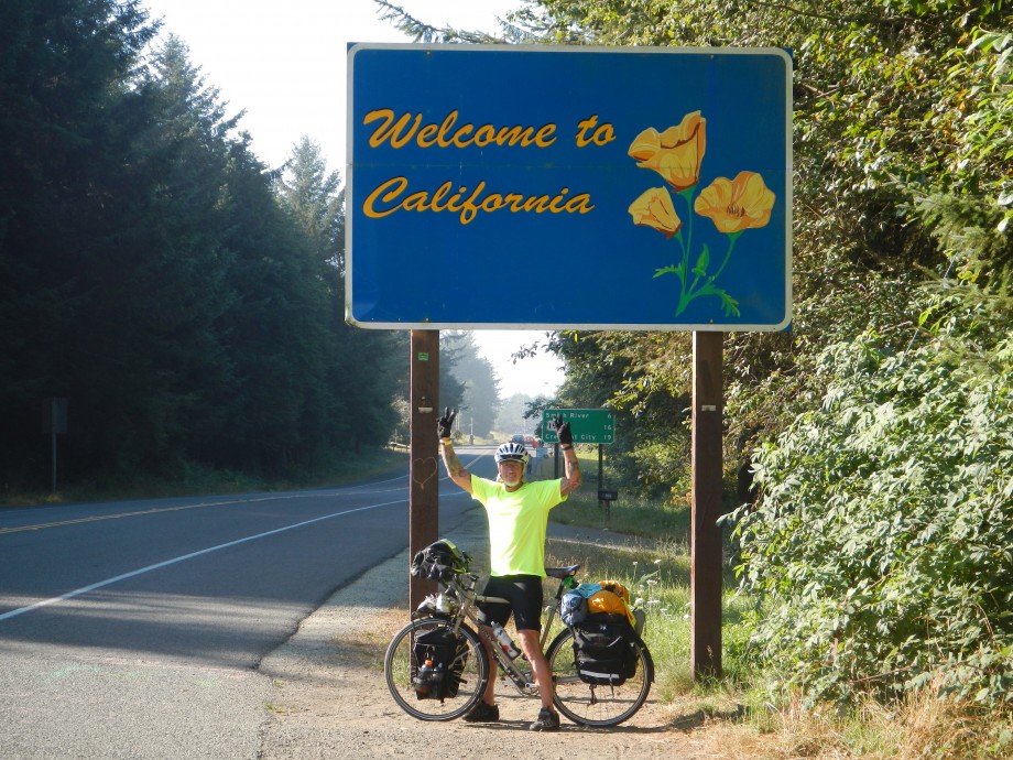
A very welcome milestone along my way to San Francisco. Not much change in scenery as the coast looks much the same as Oregon at this point. The biggest change is the prices in California are higher for everything! What’s up California with all the taxes, love your state but could never afford to live there. Politics aside, California is the most beautiful state and is the largest and with most diverse scenery on the route. Check out map data day 23, I found this really neat little cafe in Mendocino California with organic coffee, baked goods and sandwiches. The Good Life Cafe is on Lansing Street and was a great way to spend an hour getting my caffeine fix and a warm fresh organic muffin. Leaving the coast and entering the redwood forest was an OMG moment for me. Camping in the redwoods, waking up and watching the sun come up over the trees was simply awe inspiring! Early in the morning before the traffic begins was the most serene place I have ever cycled, it was so quiet, so beautiful and very calming to cruise through the area on a bicycle. Here are some photos of the area.


Moving on south, camping at the hiker-biker sites at state parks, meeting other cyclist and the excitement of cycling across the Golden Gate Bridge was all making big smiles for me. I rode into Sausalito and had lunch with several other cyclist on our way to San Francisco. I stopped and took the required photos before crossing the Golden Gate Bridge and then realized how uneventful crossing the bridge is. Actually is was kind of a let down, dodging the walkers and the tourist on the rental bikes made for an event I don’t really care to repeat. It is one of those things you have to do once in life but now that I’ve been there done that, I don’t care to do it again. Here are the photos going into San Francisco with the Golden Gate Bridge in the background.

Golden Gate Bridge

Summary-The Northern Pacific Coast Highway lives up to its reputation as one of the most beautiful and exciting cycle routes in the US. You could ride the route in 14 days on a short vacation or take 30 days with lay over days to see local attractions. There are lots of campgrounds, motels, cafes and small towns to explore along the way. It is also a route I recommend for families with children, european tourist, or groups of organized riders. I began on August 1st from Vancouver, however I recommend you start after the Labor Day holiday due to the traffic. Begin around September 15th and most RVs are off the road and the kids are back in school.


Cautions- Safety and security are number one on any adventure. Crashing sucks and having your bike stolen along the way is a big time bummer to say the least. I would be remiss if I didn’t at least discuss it here. There are dangerous areas on any bike route, it goes with saying to pay attention to traffic and watch out for hazards on the route. If you have been cycling for any time at all you understand what to look out for. There are sections on this route that you are riding in traffic with no bike lane. Pay attention, have rear flashing lights and use common sense and you will be fine.
Security-If you leave your bicycle and gear unattended in any of the cities, especially Seattle and San Francisco it will be stolen. Period.
These areas have professional bike thieves that steal bikes for a living. Cable locks, don’t waste your time. Thieves carry 12′ bolt cutters in a backpack that cut the cable and gone in less than 10 seconds. Lock your bike to a fixed object with a U-Bolt lock around the frame and a cable running through both wheels and onto the U-bolt lock. I would even throw the chain off to the inside of your front sprocket so if they cut the locks they cannot ride it off.
Never leave your bike out of your sight in large cities.
If you have a Brooks saddle, remove it and take it with you, thieves will steal it. I have a special passion for bike thieves, but do not let this discourage you from your tour. Thieves are everywhere in every country, use common sense and enjoy your adventure. See my blog post on “Wonderful Wanderers” The world is full of nice people and you will meet many Wonderful Wanderers on the Pacific Coast, don’t let the occasional asshole mess up your mojo.

Haight Ashbury

I fully agree that if you leave your bike unattended in San Francisco and region, even for minutes, it will be stolen. I had TWO thieves attempt to steal my bike on differing occasions right from me. In one case, I was taking my bike with me into a public toilet and a stranger walked up and told me he would “watch” my bike for me… to which I tactfully said “I can take it with me” but really wanted to say FU. The second time, the guy walked up and scanned my bike for Garmin computers or anything he could take and run… as he and I were eyeball to eyeball through glass of a coffee shop window. He just smirked at me as he walked away.
That said, your mapping data points are something I can use but I see segments missing.
i.e. Day 9 & 12, for example.
What happened to the missing data points?
I hope to ride the coast in full toward Sept of 2016.
LikeLike
Totally agree with your comments on bike thieves in big cities. Never let your bike out of your sight if possible. The missing data points are from problems syncing the Garmin data. I lost a few days when the upload locked up and I lost the data. I suggest using maps from Adventure Cycling Association, they are the go to way for bicycle travel.
LikeLike
Going to start coastal ride from Sumas, WA, in May using ACA maps loaded onto Garmin. Thanks for your info on your blog. I’m not sure how to ride in rainy weather though. Any tips on that? I’ll pack chain lube & installed fenders but anything else? Too hard to mess with Canada in these post 9-11 days with government paranoia so high (while they nearly ignore the entire Mexican border).
LikeLike
Jason,
I agree with the crossing the border issues. FYI, I took Amtrak train from Seattle to Vancouver BC and was detained at the immigration office in Vancouver. They asked why are you coming into Vancouver with a one way ticket. I explained I shipped my bicycle from Florida and was here to pick it up and ride back home. Border agent thought that was suspicious so I spent the next 20 minutes in a little room explaining I was not a terrorist invading Canada. Vancouver is a beautiful city and the most cycle friendly place I have ever been. If I had it to do again I would just start at the US border.
As for the rain in the northwest, on this tour I used SKS Longboard fenders front and rear. I now do not use fenders for touring. When it rains you get wet and the fenders do not do anything to keep you dry. They do keep some of the road spray and grit from being thrown up onto your chainrings but in my opinion fenders are more problem than a solution. I kept banging them up going over curbs, (Front fender lip is very low to the ground), and I was always making small adjustments to the screws. I don’t use a kickstand so many times I just lay my bike over on the ground. Seems like the fenders were always getting tweaked one way or the other. I know many people swear by fenders but for me, no fenders. On my 16 week tour I think it rained maybe 8 days.
I posted my Garmin data so other riders could use it but be advised I do make a few minor wrong turns and you will see this on my data. So I recommend using ACA cycling maps in addition to the GPS data. I find the state paper maps are very useful also and are usually free from tourist offices. Happy trails!
Bill
LikeLike
Saw your blog about your trip. Looked amazing and was inspiring.
I’m from New York City and I want to bike from Vancouver or Seattle depending on how ambitious I feel but my first obstacle /problem is that I don’t own a touring bike. Before your travels or along your travels, did you ever hear or meet anyone that may have bought their bike on the west coast and rode it down to sell it off to someone else after riding?
Do you have any recommendations for us? Ever heard of anyone renting and riding down? (know that sounds crazy but thought I’d ask) Is buying and reselling our best bet?
Looking forward to your response.
Thanks!
LikeLike
Thanks for sharing your info and data on the PCR. Do you have the official start point address? I tried to glean that off of your Garmin data, without success. I’m leaving at the end of the week. Cheers.
LikeLike
I do not have the official address. The totem pole (Official start point) is located in a park. Sorry I can’t tell you more.
I am closing this page soon, my new website with all content is up and running at SpotWhiteAdventures.com
Thanks,
LikeLike